In a few words...
Mapping the 15 Minute City
The functionality and practicality of a city has never been so evident as in the last months, which the entire population had to go through a strict lockdown due to spread of Covid-19. Many countries have applied severe rules which has also limited the circulation of individuals within a certain radius of kilometers, having their home as the zero point.
The better structured a block is, in terms of amenities and facilities, the shorter the distance people have to commute, and as a consequence, there is less human contact. However, this idea of multilayered and diverse blocks is not a movement that arose due to the pandemic, this concept started to be developed as a contraposition to modernism principles, which prioritised a strict functional zoning, by centralising services, residential and commercial activities in specific points, and the connection between them was based on large boulevards, resulting in a typical car-driven urban fabric.
In many big cities, there is an urgency to rethink these traditional modernist blocks and also to plan the upcoming rising of new urban developments, in order to build up more mixed-use neighbourhoods where locals find more amenities within a block by commuting shorter distances.
Looking specifically at the European context, the city of Paris has focused on a pre existing urban movement in order to brainstorm solutions for decentralising the city, called ‘‘The 15-minute city’’ or ‘‘The city of proximity’’.
According to Carlos Moreno, a scientific director and professor specialising in complex systems and innovation at University of Paris 1, the 15-minute concept was developed primarily to reduce urban carbon emissions, reimagining our towns not as divided into discrete zones for living, working, and entertainment, but as mosaics of neighbourhoods in which almost all residents’ needs can be met within 15 minutes of their homes either on foot or by bike.
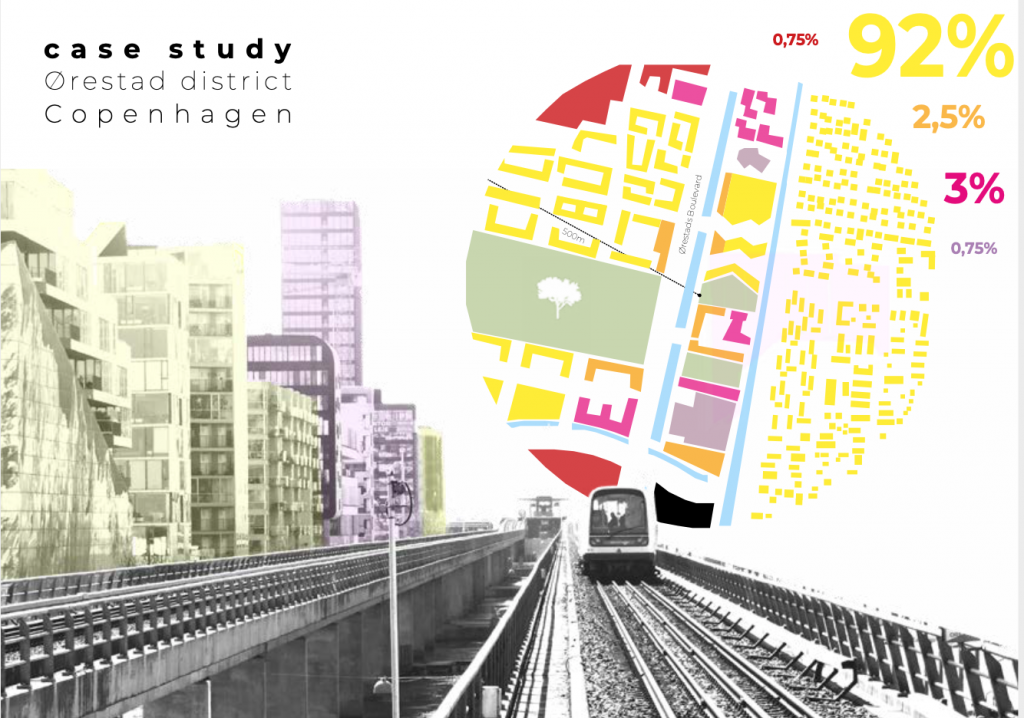
The manual motivates you to use the 15-minute city concept with public space analysis in order to get to know your project, on either the block or city scale, more in depth to critically investigate the existence of mixed-use development in both accessibility and human experience perspective.
If you want to stay up to date about the newest placemaking trends within the network, feel free to subscribe to our newsletter!
Cookie | Duration | Description |
---|---|---|
cookielawinfo-checkbox-analytics | 11 months | This cookie is set by GDPR Cookie Consent plugin. The cookie is used to store the user consent for the cookies in the category "Analytics". |
cookielawinfo-checkbox-functional | 11 months | The cookie is set by GDPR cookie consent to record the user consent for the cookies in the category "Functional". |
cookielawinfo-checkbox-necessary | 11 months | This cookie is set by GDPR Cookie Consent plugin. The cookies is used to store the user consent for the cookies in the category "Necessary". |
cookielawinfo-checkbox-others | 11 months | This cookie is set by GDPR Cookie Consent plugin. The cookie is used to store the user consent for the cookies in the category "Other. |
cookielawinfo-checkbox-performance | 11 months | This cookie is set by GDPR Cookie Consent plugin. The cookie is used to store the user consent for the cookies in the category "Performance". |
viewed_cookie_policy | 11 months | The cookie is set by the GDPR Cookie Consent plugin and is used to store whether or not user has consented to the use of cookies. It does not store any personal data. |